Co-Authors:
Kevin Garrett, NOAA/NWS
NOAA Data Assimilation Strategy Tiger Team Lead
Sergey Frolov, NOAA/OAR
NOAA Data Assimilation Strategy Tiger Team Co-Lead

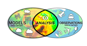
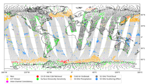
In environmental analysis and prediction, data assimilation (DA) is the process that combines observations with model data to produce a best estimate of the Earth system state at a given time, also known as the analysis. DA systems are critical to providing analyses both for nowcasting and situational awareness, as well as for the initialization of numerical weather prediction (NWP) and Artificial Intelligence-based (AI) forecast systems. As significant as advances in DA capabilities has been over recent decades, such as expanding the types of observations assimilated and the environmental phenomena observed, many challenges still exist. For example, the volume of data assimilated is a small percentage of data provided across the Earth global observing system; DA algorithms, constraints, and assumptions, in some cases, limit the information content extracted from observations; and gaps in DA-related subject matter expertise inhibit innovation from advancing DA capabilities.

Sounding Unit (AMSU-A) for a 12-h assimilation window for the Global Data Assimilation System
(GDAS).
Concurrently, the global observing system for environmental observations is growing, and becoming more complex. Data volumes are increasing rapidly, as are the types of observing systems, and this trend is expected to continue over the next decade. In addition, the need for accurate, continuous environmental information is growing across both private and public sectors.
To address these compounding challenges, the National Oceanic and Atmospheric Administration (NOAA) recently published the NOAA Data Assimilation Strategy: 2024-2033 Strategic Plan. The strategic vision for NOAA’s DA over the next 10 years is “to serve societal needs through fully-coupled and continuous Earth system data assimilation capabilities which maximize the impact of environmental observations.” The vision will be realized by four overarching goals:
- Build the required infrastructure for continuous development and integration of data assimilation workflows. NOAA will rethink how it deploys and operates the end-to-end data assimilation process, toward continually updating the Earth-system state.
- Maximize the use, value, and impact of Earth system observations. NOAA will leverage new techniques such as AI to extract, to the maximum extent, all information content from available environmental observations to inform Earth system analyses.
- Transform and build the next-generation DA workforce with new skills beyond traditional DA expertise. This includes data scientists, software and cloud engineers, and experts on new sensor technologies. NOAA will leverage public and private partnerships to address these skill gaps.
- Optimize organizational efficiencies across the research, development, and operational transition of new capabilities across the DA enterprise. NOAA will improve the alignment of research and operational priorities and work more seamlessly to integrate new observations and new techniques into our DA systems.

The release of the strategy will be followed by developing implementation plans to address each of the strategic elements above. The next-generation DA infrastructure for the Unified Forecast System (UFS), known as the Joint Effort for Data assimilation Integration (JEDI), will be a key tool to support the goals outlined in the strategy. In addition to the JEDI infrastructure technological and scientific innovations will be needed to efficiently process and synthesize information from environmental observations in order to realize the vision of a continuously updating Earth system analysis that can feed the downstream applications such as rapidly updating ensemble prediction systems across the family of the UFS applications and derived operational systems.


