Unified Forecast System (UFS) Community Modeling Support
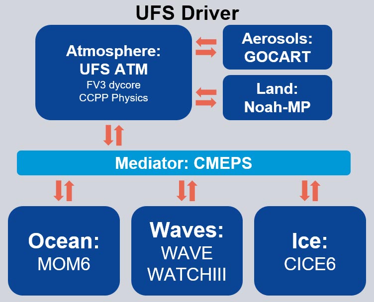
NOAA is using a community modeling infrastructure framework to drive its unified modeling system called the Unified Forecast System (UFS), composed of various applications and component models. These modeling components include the Modular Ocean Model version 6.0 (MOM6), the Wave Watch III (WW3) wave model, land surface models, the Finite-Volume Cubed-Sphere (FV3) dynamical core (dycore), and more. In addition, there are infrastructure components such as the Earth System Modeling Framework (ESMF) libraries, the Community Mediator for Earth Prediction Systems (CMEPS) coupling infrastructure, and the Flexible Modeling System (FMS). There are also applications that connect two or more of these components together to create an end-to-end modeling system, e.g., with pre- and post-processing, a computational model, and potentially other elements, like data assimilation and verification. For example, the UFS Weather Model uses CMEPS to connect the atmospheric system (FV3 dycore and physics suites) with other Earth systems, like waves and atmospheric chemistry.
To support community development of the UFS, the entire modeling suite (components and applications) needs to follow the community development paradigm, i.e., open development repositories with proper documentation and code managers for all of the components as well as Continuous Integration (CI) teams for testing the applications as the individual components are upgraded. This is not just a NOAA-wide enterprise — it includes collaboration with others. This project supports the Continuous Integration process for the UFS Weather Model, including all UFS components, and the NUOPC (National Unified Operational Prediction Capability) caps (FORTRAN modules that serve as the interfaces to models) for the components, to ensure that it is up to date for major UFS weather applications (e.g., Global Workflow, Subseasonal-to-Seasonal, Short-Range Weather, and Hurricane Applications). EPIC has been supporting the collaborative UFS Community modeling infrastructure project since 2019.
Data Assimilation
One of the major sources of error in weather and climate forecasts is uncertainty related to the initial conditions that are used to generate future predictions. Even the most precise instruments have a small range of unavoidable measurement error, which means that tiny measurement errors related to atmospheric conditions and instrument location, for example, can compound over time. These small differences result in very similar forecasts in the short term (i.e., minutes, hours), but can cause widely divergent forecasts in the long term. Errors in weather and climate forecasts can also arise because models are imperfect representations of reality. Data assimilation systems seek to mitigate these problems by combining the most timely observational data with other sources of data, such as historical data and/or previous forecast results, to provide an analysis of possible atmospheric states and the probabilities of each. Data assimilation systems can use techniques including stochastic physics, which applies randomized perturbations to the physical tendencies or the physical parameters of a model, to compensate for model uncertainty. When combined with an “ensemble” of model runs (many forecasts with slightly different conditions), data assimilation helps predict a range of possible atmospheric states, giving an overall measure of uncertainty in a given forecast.
NOAA’s operational data assimilation system for the Global Forecast System (GFS) uses the Finite-Volume Cubed-Sphere (FV3) dynamical core. The FV3 currently utilizes a hybrid 4D Ensemble-Variational (4D EnVar) solver designed to represent the analysis and background error covariances, along with stochastic physics.
EPIC is involved in a number of projects that seek to improve data assimilation (DA) capabilities. In particular, EPIC provides support to the Joint Center for Satellite Data Assimilation (JCSDA) on a range of Projects (2019-2025);JCSDA’s Annual Operation Plan (AOP) provides a comprehensive description of several key initiatives supported by EPIC. These initiatives cover major themes such as:
Community Radiative Transfer Model (CRTM) improvements (VIS, IR, MW, Radar), adding transmittance coefficients for new satellites, and updating surface emissivity Look Up Table (LUTs)