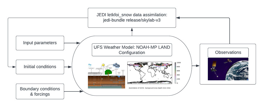
The Earth Prediction Innovation Center (EPIC) and the Unified Forecast System (UFS) community are proud to announce the public release of theUFS Land Data Assimilation (DA) System v1.1.0. This release is an update to the inaugural public release v1.0.0 from March 2023 and reflects changes currently available at the head of the UFS land-DA_workflow development branch. In the Land DA System, the Noah-MP land surface model (LSM) and the Joint Effort for Data assimilation Integration (JEDI) software stack are used to assimilate snow depth data via the Local Ensemble Transform Kalman Filter-Optimal Interpolation (LETKF-OI) algorithm. Key feature updates for this release include:
Updated Singularity container (ubuntu20.04-intel-ue-landda-v1.1.0.img) to support the changes described above
Updates to spack-stack and module files to support the UFS WM build
These updates chart a path forward to unify the Noah-MP forecast model code base with the UFS Weather Model under a continuous release paradigm, where updates are added at consistent intervals to improve the code and add capabilities. This continuous release iteration will not change how users run the Land DA System from the first inaugural release, but it sets the stage for significant new capabilities in the Land DA System.
The Land DA System is an offline version of the Noah Multi-Physics (Noah-MP) land surface model (LSM) used in the UFS via the Common Community Physics Package (CCPP), and it is currently being tested for operational use in GFSv17 and RRFS. The offline Noah-MP LSM is a stand-alone, uncoupled model used to execute land surface simulations. In this traditional uncoupled mode, near-surface atmospheric forcing data are required as input forcing. This LSM simulates soil moisture (both liquid and frozen), soil temperature, skin temperature, snow depth, snow water equivalent (SWE), snow density, canopy water content, and the energy flux and water flux terms of the surface energy balance and surface water balance. Its data assimilation framework uses the Joint Effort for Data assimilation Integration (JEDI) software stack (Skylab v3.0), which includes the Object-Oriented Prediction System (OOPS) for the data assimilation algorithm, the Interface for Observation Data Access (IODA) for observation formatting and processing, and the Unified Forward Operator (UFO) for comparing model forecasts and observations. JEDI applies the Local Ensemble Transform Kalman Filter-Optimal Interpolation (LETKF-OI) algorithm to combine the state-dependent background error derived from an ensemble forecast with the observations and their corresponding uncertainties to produce an analysis ensemble (Hunt et al., 2007). As part of this release, the Land DA system has been refactored to enable the build of Noah-MP as a component model, a feature to be included in future releases.
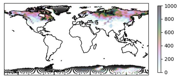
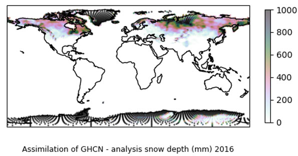
Schematic Diagram of Land DA SystemAssimilation of GHCN – Analysis Snow Depth (mm) 2016An updated User’s Guide is available to provide further information about the Land DA System and instructions for running and testing the system. Data files required to run Land DA are available to the public in the Land DA data bucket. Interested users can get support by submitting a question through GitHub Discussions.
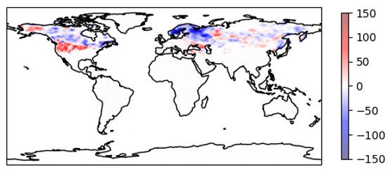
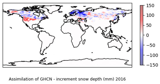
Assimilation of GHCN – Increment Snow Depth (mm) 2016
This continuous Land DA release is a collaboration between the Earth Prediction Innovation Center (EPIC), the Environmental Modeling Center (EMC), the Physical Sciences Laboratory (PSL), and the Joint Center for Satellite Data Assimilation (JCSDA). It uses Joint Effort for Data assimilation Integration (JEDI) software developed by the JCSDA and the CCPP software developed by the Developmental Testbed Center (DTC). Publicly available data is provided via an AWS S3 bucket established as part of the NOAA Open Data Dissemination (NODD) Program.
This release was funded by the NOAA Weather Program Office’s EPIC Program, the National Weather Service Office of Science and Technology Integration (OSTI) Modeling Programs, and the NOAA Disaster Supplemental Program.
View the Land Data Assimilation System page on the EPIC Community Portal.